Packington HS2 Residents Group update 2025
There are also 17 fact-sheets available with generic answers (not particular to Packington) at
https://www.hs2.org.uk/documents/collections/hs2-phase-2b-factsheets/
The basic route was confirmed last year, but detail is still being worked on by HS2. As well as the rail line, we can try to influence the construction process, and the noise and visual impacts on Packington residents.
Tell us what you think or what you notice – together we can reduce the impact of HS2 on our village.
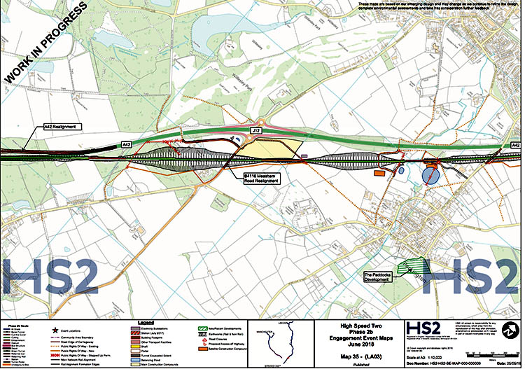
Packington HS2 Residents Group update – Explanation of the Packington Map in the HS2 documents of 4 June 2018
HS2 released their draft design online on 4th June 2018, ready for their series of roadshows running 4th June to 14th July.
Summary of maps available on-line
The HS2 maps put detail onto the route announced in July 2017. They are work in progress – the design will continue to be altered & tweaked throughout the year.
The maps don’t show any sound barriers / earthworks to hide the HS2 line. They don’t show the roads that construction traffic will use to travel to / between construction sites.
The Packington Map is on page 3 of 4, number 35, of this document LA03 showing the route between Appleby Parva and Ashby de la Zouch.
Starting at the left of the page, and moving right…
1). The first area to note is around Five Lanes End
Due to the massive cutting at Five lanes end (which should be a tunnel instead) the Willesley Woodside lane will be removed – The route to Hicks lodge will connect instead to Measham road beside junction 12 of the A42. That removes the historic Trigonometric point and the Severn Trent Water reservoir on that lane.

2). Next is there will be a bridge added near Junction 12, for the B4116 Measham Road – As the bridge is to be where the road currently is, HS2 will either have to shut the road for a few months whilst building the bridge, or put in a temporary road alongside.
3). Beside Junction 12 of the A42 there will be a main construction compound for the area. (The yellow area, which will be between the A42 and the solar farm). It will be there for approx. 5 years – there will be peaks and lulls in construction. Having this right beside the A42 Junction, should help keep construction traffic away from Packington’s roads.

4). There will be an electrical substation behind the sewage plant, where the railway comes off a 4m high embankment – The position of this substation cannot be moved any distance due to its function. Note that just here, there could be a lot of flashes from the overhead lines that the trains take their power from, as trains move from one electrical section to the next.

5). There is then a cutting through Plant’s Hill, that will be visible from any part of Packington that can see across to Plant’s farm and the hill.
6). Vicarage Lane, which is a public right of way, a bridleway and a farm access track, will be diverted up the hill onto a bridge over the HS2 line, before re-joining the current bridge over the A42. For Packington, this is better than a tunnel under the line, because…
-
Even the largest farm vehicles will be able to cross the line.
-
There is less risk of antisocial behaviour / graffiti, as the bridge should be visible from the surrounding area.
-
It allows the line to be lowered, to hide it more from Packington.
-
The sewage pipes across the hill
-
The bridge could help reduce the visual impact of the cutting through Plant’s hill.
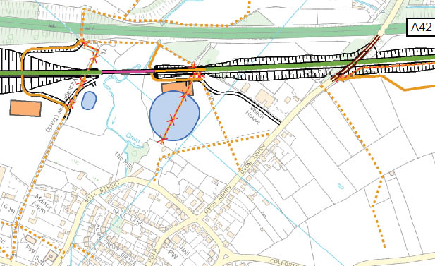
7). The Gilwiskaw Brook viaduct section of the line is lower than the sections either side, therefore water will run off the line into the Brook – To slow any flood of water, HS2 plan to create 2 water balancing ponds, one each end of the viaduct, on Packington side of the A42. In practical terms these are more likely just to be cut out areas of ground (within the fields, outside of the Gilwiskaw flood plain) for water storage, that are dry most of the time.
8). The maps still show the high and long viaduct across the Gilwiskaw (the fuchsia colour piece of line) – this will have a substantial visual & noise impact on Packington and remains one of our key mitigation points. We believe alternative solutions could be found by HS2 which would significantly reduce the permanent impact of a viaduct.
9). There will be 2 smaller construction compounds (orange areas) one the Packington side, one each end of the Gilwiskaw viaduct for a year or 2 whilst they build the viaduct. These will be visible from Packington. It is unclear how construction traffic will get to these compound as present.
10). Currently the proposal is the footpath near Beech House will be diverted under the viaduct.
(This brings with it risk of Graffiti / anti -social behaviour)
11). The bridge to take Ashby road over the railway is shown to be built on the same alignment as the current road. This will mean that HS2 close Ashby road to vehicles for several months. Maintaining access via Ashby Road significantly reduces the impact on residents. HS2 is saying that if they built the new bridge beside the current road, so the road could stay open, it would not line up with the current A42 bridge & they would have to build a new bridge across the A42, which they say is poor value for money. We will continue to push HS2 to find a way to keep Ashby Road open throughout construction.
11). Either side of Ashby road, the HS2 line is in a shallow cutting – You will still hear the trains, and will see the upper half of the carriages of the trains. We are pushing for the line to be lowered here, and tree lined embankments built up to reduce the noise of trains and to hide them and the girders that hold the overhead power lines.
For those interested in the area on the Maps For Ashby, New Packington and beyond, which is on Page 5….
1). In New Packington, Leicester road bridge will be built on the same alignment as the current Leicester road, again as HS2 do not want to spend money on a new bridge over the A42. It is likely Leicester road will be shut to traffic for some months whilst they build the new HS2 bridge – We have been told it will be shut at a different time to Ashby road being shut.
2). There will be a small construction compound approx. behind Tudor Motors – it is assumed this will be used for a year or two, whilst the Leicester road bridge and the Ivanhoe railway line bridges are built. It is unclear which roads the construction traffic will use to get to this compound.

3). A bridge to take the Coalville road, (A511) across the HS2 line is show on the same alignment as the current road – it is unclear how HS2 plan to keep this road open during construction of the bridge, but give the volume of traffic that uses this road, it would be ridiculous to divert it onto other local roads.
4). The Loughborough road (A512) at the A42 Junction 13 roundabout will be permanently diverted for approx. ½ mile. As the new section will be built offline (not where the current road is), it is unlikely the road will be shut to traffic for any great time.
3). There will be a main construction compound at J13 of the A42 – It is shown as using the fields & not the old Lounge coal disposal site. Again, it is good that this compound is directly off the A42 junction, to reduce the risk of construction traffic on the smaller roads.
Packington HS2 Residents Group continues to have productive meetings with HS2, during which we put forward measures to mitigate the impact on Packington both during the lengthy construction phase and once the line is operational.
Our main mitigation proposals are:
Line – for the line to be lowered through Packington from the current 4m high proposal & for the viaduct to be replaced with a cut and cover tunnel. These changes would substantially reduce the visual and noise impact in Packington as well as the permanent blight on the village. HS2 have committed to review their flood data which is the main influence on the height of the line.
Construction – we continue to push alternatives to construction traffic using local roads. HS2 are now aware of the importance of keeping both pedestrian & vehicle access along Ashby Road. Vehicle access will require an off line bridge across the A42 which attracts a cost. However it would substantially reduce the disruption to residents during the months/ years of construction.
 Yes.
Yes.
HS2.
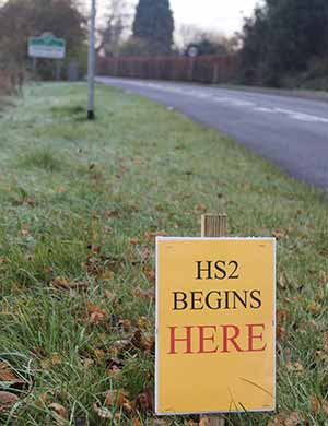
To start 80 metres outside our village.
The view at left is from Ground Zero

You know the Ashby Road, and the road sign at the start of our village